Showing posts with label geography. Show all posts

Friday, January 22, 2016

Last Chance to See

The Aye-Aye. Not all lemurs are adorable. 


Douglas Adams is best known as the author of the Hitchhiker's Guide to the Galaxy, which is a series of books (and many other media) that had a profound influence on my developing sense of humor as a goofy sixth grader. The idea that you could blend science fiction with Monty Python-esque humor blew my mind, particularly because I realized that a lot of it was clearly going right over my head. For example, as a twelve year old, I had no idea what bureaucracy was, nor how absurd and maddening it can be to navigate. But because it was a favorite topic of satire for Adams, it gave me an intriguing glimpse of my own future of tax returns, mortgage applications, and endless visits to the DMV. 


Mark Carwardine and Douglas Adams

As much as I loved the fictional universe that Douglas Adams created, it is his writing about our own world that has continued to resonate with me. In 1985, a magazine editor had the bright idea of teaming Adams up with a photographer and a naturalist to attempt to spot an extremely rare and endangered lemur in the wild. I'll let Mr. Adams introduce the trip:

This isn't at all what I expected. In 1985, by some sort of journalistic accident, I was sent to Madagascar with Mark Carwardine to look for an almost extinct form of lemur called the aye-aye. None of the three of us had met before. I had never met Mark, Mark had never met me, and no one, apparently, had seen an aye-aye in years. 
This was the idea of the Observer Colour Magazine, to throw us all in at the deep end. Mark is an extremely experienced and knowledgeable zoologist, working at that time for the World Wildlife Fund, and his role, essentially, was to be the one who knew what he was talking about. My role, and one for which I was entirely qualified, was to be an extremely ignorant non-zoologist to whom everything that happened would come as a complete surprise. All the aye-aye had to do was do what aye-ayes have been doing for millions of years - sit in a tree and hide.

The aye-aye. 
The experience was transformative. Adams and Carwardine decided to continue their partnership, and spent the better part of a year traveling the globe in an attempt to see (and draw attention to) a collection of animals who were teetering on the edge of extinction. The book that emerged from these travels is called Last Chance to See. The book is both entertaining and sobering. In the time since its publication in 1990, one of the species they searched for (the Yangtze River Dolphin) is now believed to be extinct. 

Sadly, Douglas Adams died in 2001. However, his passion and advocacy inspired many, including his friend Stephen Fry. In 2009, the BBC aired a six part documentary series, in which Fry and Mark Carwardine retraced their journey, checking in to see how each species had fared over the decades. 

By now, you're perhaps wondering if I'm ever going mention the fine students of Summers-Knoll, and what any of this has to do with them. I am, indeed! 
We read the first chapter of Last Chance to See in class, which is a fun and useful primer for evolutionary biology, plate tectonics, ecology, conservation, and more. It's titled "Twig Technology," and I essentially want to quote the entire thing. Instead, here are three paragraphs that I have found delightfully concise and informative. 


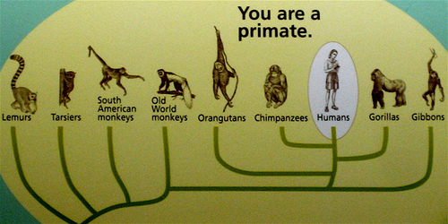
Like virtually everything that lives on Madagascar, [the aye aye] does not exist anywhere else on earth. Its origins date back to a period in earth's history when Madagascar was still part of mainland Africa (which itself had been part of the gigantic supercontinent of Gondwanaland), at which time the ancestors of the Madagascan lemurs were the dominant primate in all the world. When Madagascar sheered off into the Indian Ocean it became entirely isolated from all the evolutionary changes that took place in the rest of the world. It is a life raft from a different time. It is now almost like a tiny, fragile, separate planet.  
The major evolutionary change which passed Madagascar by was the arrival of the monkeys. These were descended from the same ancestors as the lemurs, but they had bigger brains, and were aggressive competitors for the same habitat. Where the lemurs had been content to hang around in trees having a good time, the monkeys were ambitious, and interested in all sorts of things, especially twigs, with which they found they could do all kinds of things that they couldn't do by themselves - digging for things, probing things, hitting things. The monkeys took over the world and the lemur branch of the primate family died out everywhere - other than Madagascar, which for millions of years the monkeys never reached. 
Then fifteen hundred years ago, the monkeys finally arrived, or at least, the monkey's descendants - us. Thanks to astounding advances in twig technology we arrived in canoes, then boats and finally aeroplanes, and once again started to compete for use of the same habitat, only this time with fire and machetes and domesticated animals, with asphalt and concrete. The lemurs are once again fighting for survival. 

In just these three paragraphs, we found at least five different concepts to unpack and discuss. Later, after reading the entire chapter, we watched the episode of the 2009 BBC series that followed up their visit. 

If you're interested, you can view it here: 


While planning the book, Douglas Adams was able to tell Mark Carwardine where on the planet that he would like to visit, and Carwardine was easily able to find species there that were endangered and in dire need of publicity and help. Taking this as inspiration, we took stock of our own corner of the globe. 

Each student read though this list of threatened or endangered species in the state of Michigan. Then, they selected one to learn about its situation. What is it? Why is it endangered? What is being done about it? 

Having done research on their particular organism, each student is preparing a short (5-10 minute) presentation on what they learned. Some students gave their presentations to the assembled 5/6 classes over the week. The remaining presentations are forthcoming. 


Kaz discusses the Copperbelly water snake

Henry teaches us about the Eastern Massasauga rattlesnake

Oliver presenting on the Piping Plover

Niko tells us about the Northern Long-Eared Bat

After sharing what we've learned about this sampling of endangered species, we'll look toward what active steps we can take to preserve these (and many other) species in our own communities. 

The highly-specialized hand of the aye-aye. 

Friday, November 13, 2015

Week 10: What makes a border? Why do people want to cross them?


As discussed last week, we're taking a deeper look into the nature of geography and borders. 


On Monday, we spent some time examining and discussing this image, making note of the various physical features. 


People pointed out mountain ranges (green on one side, less so on the other), lakes, rivers, areas that seemed greener than others, and coastlines. We then started talking about these features in terms of what it might mean to live there. Rivers irrigate crops. Oceans allow ports. Deserts can be inhospitable. Where would you want to live on this map? Where would you want to avoid? 

We also talked about how these features might form natural borders for people (and other life!). Oceans, mountains, and deserts have historically been difficult to cross, thereby separating people, cultures, languages, and religions through long stretches of history. People living on one side of a vast desert or giant mountain range might have very little in common with the people who live on the other. 

We eventually looked at this image with the political labels turned on: 

Before the labels were revealed, a few kids had recognized the region we were examining, but they knew little about it. For example, no one knew about the longstanding tensions between Pakistan and India. We discussed some of the current and historical issues in this part of world as a way of illustrating how the physical and the cultural can intersect and influence a border. 

With all of this in mind, we then examined maps of a fictitious landmass. Everyone was tasked with the following challenge: 

Given these physical features (coastlines, rivers, and mountains):


... and these regions of differing religions:


... and this map of the languages spoken in each region: 


... what borders do you might imagine would exist on this landmass? 


Here's a sampling of what people came up with: 


As you can see, there were plenty of ways to divvy things up. 

Later, we shared and discussed our maps, making note of similarities and differences. We talked about what was challenging about creating borders, and what influenced our decisions. How important was it to have a river or coastline for each country? How did religion or language enter into each borderline? What role did the mountains play? 

Then we extrapolated further: What would it be like in the countries where there was one predominant religion, but also small pockets of another? What about countries with more than one language? Would citizens coexist peacefully, or would there be friction? What if a country with a minority population in its borders lacked a sufficient water source? What if there was a scarcity of farmable land? 

We unanimously agreed that this was indeed a tricky process. It was easy then to see how the evolution of nations and states in the real world has been even more complicated and messy. 


All of this informed a discussion about a contemporary issue that is currently on the minds of many: The mass influx of refugees to Europe. 

Visit this link to view an astounding animation of the number of refugees entering Europe from 2012 to the current day. Here's a screenshot of a moment in time, but you'll really want to check out the animation in motion. It's a little staggering: 


Each white dot represents 25 people. We watched the animation a few times and discussed many questions: 
Why are so many people going to Europe? What causes someone to leave their home country for another? Why are so many people fleeing Syria? What about Somalia? What's happening in sub-Saharan Africa in general? And why are so many people going to Germany? Why France? 

We discussed some of what's been going on in those parts of the world, which hopefully provided at least some small amount of context for the tragedies that have since been in the news over the last few days. I'm sure there will be many more conversations to come next week. 

The latest development in our current read aloud book Esperanza Rising has given us another view of this issue, as Esperanza and her family have just crossed the Mexico/United States border, fleeing their own troubles for the promise of a better life in California. It will probably come as no surprise that things get complicated. 


Sunday, November 8, 2015

Week 9 in review


Yet another newcomer has taken up residence in the Middle School Commons. Drop by to take a peek at the lovely new habitat the next time you're in the building!  

It was a short week, as we had parent/teacher conferences on Monday and Tuesday. What time we did have was very heavy on Art. In addition to our two regularly-scheduled sessions, we also had an additional all-middle school gathering to hear about and see the work of visiting artist Leslie Sobel. Check out Monica's Middle School Art Blog for more info (and to see some of Leslie's work). 


In my Journalism elective, we unveiled the very first issue of the Summers-Knoll Wall Paper, which is our school-newspaper-on-a-wall. We opted to publish one large edition in a public space, rather than printing out individual copies in order to minimize the use of resources, as well as to create a space where students can gather to read and talk about the articles and features. (A blog version is also in the works...) The S-K Wall Paper is located right across from the large community chalk board as you enter the school. Take a look!  
As you can see, it's a team effort from kids ranging from 3rd grade to 8th grade. 


Last week in homeroom, we decided as a group that our collective geography skills could use some substantial work. There are a lot of ways to address this, and something that clicks for one kid doesn't necessarily work for others. One thing that has worked for at least a subset our group is a very competitive (but friendly!) attempt to get the highest possible score in the shortest possible time (with 100% accuracy) on this online Place the State game. (It's sort of like Tetris, but with states.) 

There are a few kids who have gone from near complete ignorance of the 50 states, to borderline mastery of them. (Of course, knowing the names and locations of the states is fairly arbitrary without learning more about the states themselves, but this has been an excellent first step for many kids.) 

Two kids who have consistently achieved excellent scores have been tasked with a new project: Freehand drawing all fifty states without a reference. Here's Kaz delighting in how challenging it can be: 


He has pleaded with me not to show a close-up of his work, but I can tell you that his first draft is probably substantially more accurate than most people in the country could manage. (And his second draft will be excellent.) WARNING: I've suggested that kids start challenging the adults in their life to try their hands at this. Study up! 

For inspiration, here's Senator Al Franken drawing a map of the United States of America freehand and from memory: 


Finally, in addition to making progress in our class read aloud Esperanza Rising, we're also making sure to devote chunks of class time to free reading. Student choice in reading material has a significant impact on their motivation and enjoyment. Here we see Eva flaunting the gendered implication of this anthology of short stories: 


Saturday, October 31, 2015

Hodge Podge: Week 8 in review


This was an excellent year for Eco-Fair/Homemade Halloween costumes! 

It is impossible to adequately convey everything that happens each week, which is why a lot of blog posts lately have focused on one aspect of our work. This week, I decided to try to capture a smattering of what happens from day-to-day.


The first thing we do each Monday is attend an all-school assembly. Each week, a different homeroom is responsible for sharing something with the entire school. This helps keep our community connected with all of the interesting and exciting things that are happening around the school. This week, Spencer's group talked about projects that they're working on. The morning assemblies are only about fifteen minutes, so if you have time to spare at drop-off on a Monday, come join us! (Our class is up to lead on Monday, November 23rd.) 


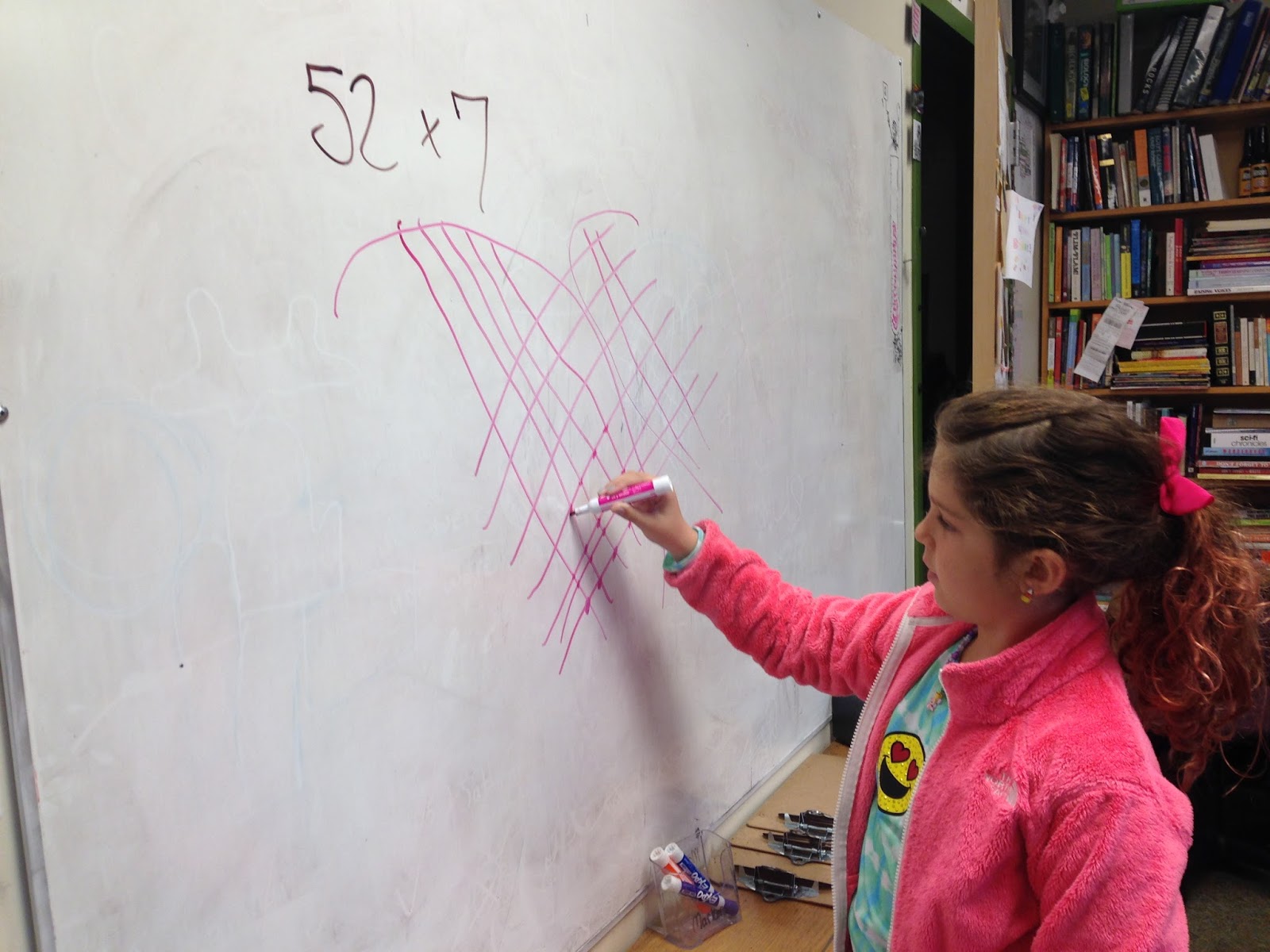
In my Math group, we spent much of the week discussing the concept of multiplication. Many of us learned the "standard algorithm," but not necessarily how or why it worked. Some of us might not have even understood that there are, in fact, many different ways to multiply numbers. 
The "standard algorithm"
Our group spent the week learning and evaluating other methods of multiplication (and also firmed up our understanding of the standard algorithm). 

The Lattice method is one that is also frequently taught. It's fairly similar to the standard algorithm, but it breaks it down into slightly smaller steps. Take a look: 


Reviews were mixed at first on this method, but once mastered, it was generally appreciated. 


Compare that with this method, which is very cool and enticing:


Everyone was instantly captivated by this one. The video above is silent (a reminder: embedded videos sometimes don't show up in the email version of this blog. Check the web version of this blog if you don't see a fascinating video of someone drawing lines to multiply above), below are two videos with verbal explanations: 


This method received high marks at first for smaller numbers, but the grouping aspect of it quickly became unwieldy for many of us with larger numbers. Many found the counting aspect of it to be laborious with larger numbers. 


Finally, here's a really cool method with many names, including Egyptian multiplicationEthiopian multiplicationRussian multiplication, or peasant multiplication.


Back in homeroom, we began a read aloud called Esperanza Risingby Pam Muñoz Ryan. The book is historical fiction, beginning in Mexico in 1926, and moving to the United States during the 1930s. In the first few days of reading, we've had conversations about social class, the Mexican Revolution, the customs and laws of inheritance ("wait, why can't Esperanza's mother inherit the land!?"), which lead all the way back to the Magna Carta. 

We'll be getting into migrant and immigration issues, the notion of organized labor, discrimination, and more. 


The book benefits from a decent grasp of North American geography, and after a brief pre-assessment, we decided as a group that we desperately needed some work on this front. 


Ella and Bora work to label their US maps. 
Completely unrelated, but I think it's funny, so here's Bora confronting Zombie Ella. 

Of course, the highlight of the week for many was Eco-Fair/Homemade Halloween. There was a strong showing of costumes this year, both in our class and across the school! 


We also did some writing, learned about simile and metaphor, worked with Scholastic News, made progress in our electives, had a rehearsal for the upcoming play, made Mason jar heart pump models in Science, worked on Music Cafe songs, and plenty of other stuff. A busy week!